
This is the story of 6 friends attempting a High Altitude Himalayan Trek ‘Rupin Pass’’ in the Autumn of 2022. They say, “Beautiful things are sometimes Incomplete”. ट्रेक थोडा अधुरा रह गया, पर दोस्ती और गेहरी हो गई!

We 6 friends hadn’t randomly landed in the quint remote village of ‘Jiskun’ in Himachal Pradesh one fine day, to begin the trek. It was a friendship of over 25 years, that brought us (Sai, Satish, Shekhar, Saket, Milind and Anup) together for the adventure of Himalayan trek…


At the personal level, my personal transformational journey had started even before the trek. While ‘high-endurance trekking in Sahyadri’ has been part of my lifestyle; but I had assumed long back that ‘running’ was never my cup of tea. Hence, IndiaHikes’ qualifying fitness criteria for the trek (running 5 km, under 32 min) was as steep as the ‘Rupin Pass’ itself for me. After real struggle for several weeks, finally I could accomplish ‘5 km running under 30 min’. Thanks to IndiaHikes for testing raising the bar high for fitness and in turn also testing the commitment.

The preparations like shopping of the gear and making the travel bookings were relatively simpler. It was heartening to see strong encouragement and support both at the home, as well as at my second home ‘Fiserv’ to be fully available and prepared for the adventure.
Entering Himachal amidst rains and govt warnings to avoid trekking
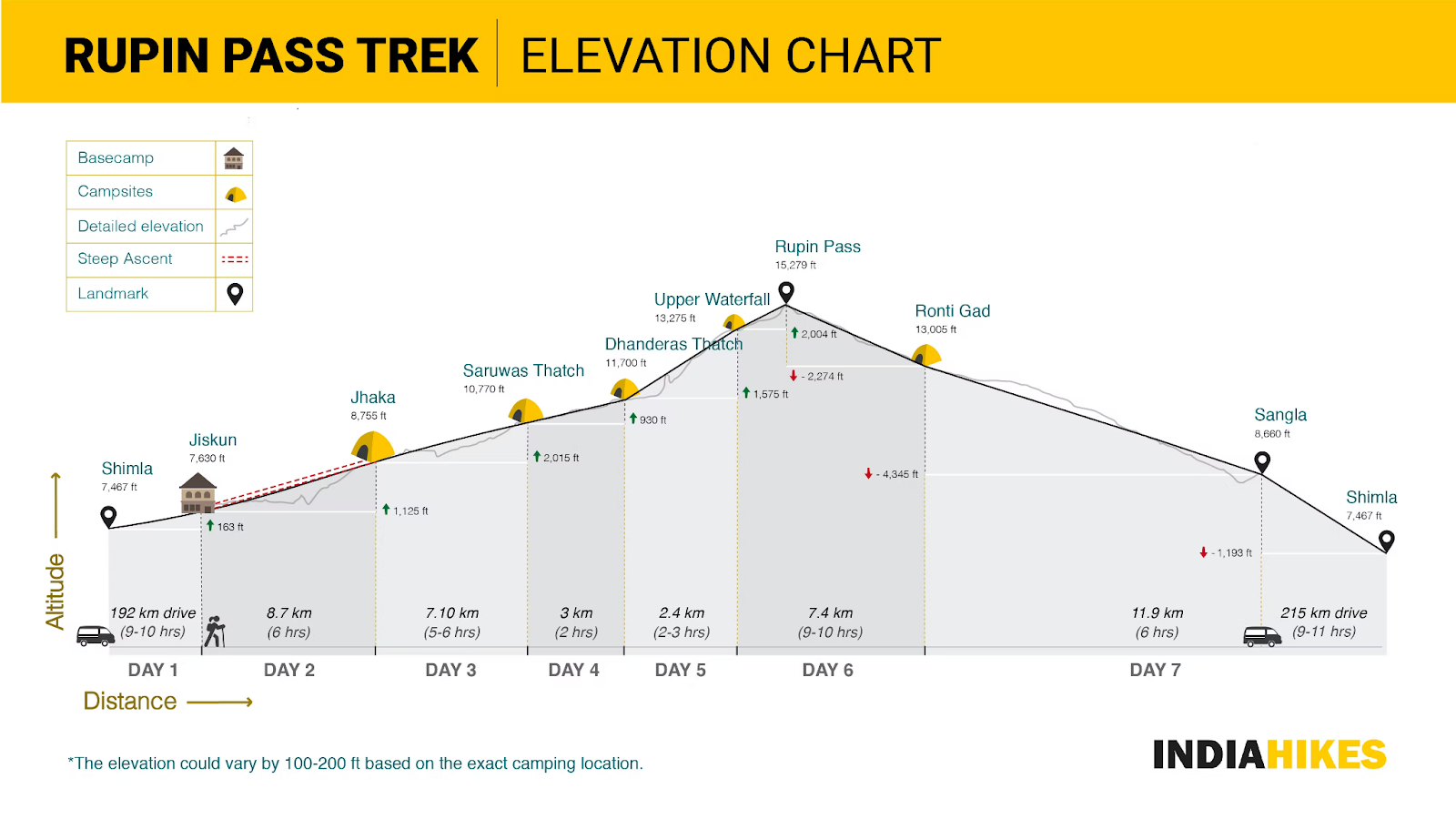
Day -3 (16-Sep): Pune - Chandigarh - Shimla - Rohru.

On Day -3 of the trek, rain was pouring all along during our long travel from the hometown of Pune, then at Chandigarh, later at Shimla and at the town of Rohru; as we entered the Pabbar river valley.

Besides heavy rain, the government advisory to "avoid trekking in Kinnaur region" added a bit more uncertainty. We kept our fingers crossed and progressed…
Swirling, muddy n' risky road through Apple plantation, Fir Forest, landslides and Chanshal Bugyal
Day -2 (17-Sep): Rohru > Chirgaon > Chanshal Bugyal (11000 ft msl) > Jiskun (base camp). 85 km. 9 Hours.
We left Rohru early morning and our vehicle traversed a narrow road next to Pabbar river and tiny villages.

On the slopes of Chanshal valley, we were awestruck with billions of red-green apples and pears. We were refreshed with juicy fresh apples.

Next was the adventurous dirt track and road-turns taking us through rich and deep coniferous forest of Chanshal valley. As a result of the vehicle activity in this thriving ‘Apple Economy’ and continuous rain, the swirling road had become muddy and extremely tricky to drive.

The road rose steep to 11000 feet above MSL to reach the meadows of Chanshal pass and bugyal, much above the tree-line. Cattle was spread across the wide grassland. Clouds and chilling breezes made us shiver...

Upon a long and scary drive, negotiating a few active landslides, we reached the picturesque basecamp at Jiskun.


We had a warm welcome at Jiskun with the smiling faces of Jiskun people n’ kids; who greeted us with ‘Namaskar’. Their humility touched our hearts.

Hospitality at SandeshJi’s Homestay was warm and comforting. We enjoyed delicious local cuisine like Siddu and pure ghee. Architecture of the kitchen and the mechanism to distribute heat from chulha throughout the room was peculiar.
Acclimatization Trek to Confluence of Nargani/ Supin and Rupin Rivers; Meeting Shepherds; Abundance of Flora.
Day -1 (18-Sep): Jiskun (base camp). 1000 ft decent-ascent. 2 hours.

We had reached the basecamp one day in advance for acclimatization. We trekked down 1000 feet from Jiskun to the river-bed of Rupin. A shepherd was driving his herd of sheep across the roaring water of Rupin on the bridge.

When asked about the weather and rain, the typical Himachal slang from the shepherd brought a big laughter to everyone.

At the the confluence of Rupin and Nargani/ Supin rivers, I was thrilled to touch the water - not only due to its chilling temperature, but also considering that I was finally able to touch the Rupin after several months of reading about her. I offered a prayer and अर्घ्य to Rupin river for the safe and comfortable trek for our entire trekking group.


We carefully observed the rich flora next to Rupin river and climbed up to Jiskun. This small hike was super helpful for us to acclimatize.

Evening sky above Jiskun wore a crown of a light rainbow on ‘Indersein Dhar’ (hill range). While we enjoyed the sun-rays resting on the hill ridges, we didn’t know that we were not going to witness sun rays for next 7 days of duration.
Trekking to 'Hanging' Villages and Glimpse into Himachal Culture and Architecture
Day 1: Trek from Jiskun to Jhaka (North-West journey). Altitude gain: 7,630 ft to 8,755 ft. 4 hours.

Finally, we met ‘Team Rupin Pass’.
- Sitting: Naveen (local guide), Samit, Saket, Shiva, Deepika, Archana, Kevin (trek leader), Priyanka, Rashi, Nikhil, Tanay, Subhash
- Standing: Akhil (local guide), Milind, Sai, Shekhar, Satish, Dinesh, Vinod, Sonu, Samruddhi, Divya, Vikas, Anup, Parag
Later that evening, our entire trekking group arrived at the base camp of IndiaHikes. It was refreshing to meet the energetic folks across India coming together for a common purpose.

A shepherd transporting 2 new-born sheep in his backpack caught our attention, at the backdrop of Indian Post.

Day 1 of our trek from ‘Jiskun to Jhaka’ started with a gradual ascend. The theme for the trek was ‘Glimpse into Culture’.

The path overlooked the spiraling Rupin river. The sound of Rupin was particularly pleasing.

The path was carved out from overhang rock face at times, making it a great experience. It was continuously drizzling all along.

Amidst deep forest, the wooden bridge made the crossing of the snow-white water stream simple.

Upon a gradual and lovely trek, we reached the traditional ‘hanging’ village of ‘Jakha’.

In the evening, we visited adjacent Dhara village to meet local people and to observe exquisite ‘kath-kuni’ (traditional Himachali wood and stone) houses, along with slated roofs.

Locals were occupied stocking grass for the upcoming harsh winter. Young boys were enjoying the game of volleyball - also part of the changing culture, while fortunately they were not engrossed in cellphones yet.

The exquisite and elaborate wooden carving listing Ramayana and Mahabharata scenes on the temple of Dhara devi and Bharatu Dev grabbed our attention. In Shravan/ August, the local folks celebrate the festival of Dhara devi. Overall, we got a nice experience of Himachali culture and architecture at Dhara.
Magnificent Fir Forest; Snaking on the banks of Rupin; Meadows of Saruwas Thatch
Day 2: Trek from Jhaka to Saruwas Thatch. Altitude gain: 8790 ft to 10770 ft. 6 hours.

On Day 3 of the trek, we embarked on the journey from Jhaka to Saruwas Thatch, which was roughly 8 km in distance where we were to gain altitude from 8790 ft to 10,770 ft. The trek theme was 'Into the Nature'.

The day's trek started off in a magnificent fir forest after Jhaka, progressing towards North-West direction. Scattered clouds on the hill tops were good for the frame, but was a cause of worry for the further trek.


Dark and deep forest started suddenly and ended suddenly. Here, the path started navigating towards North-East direction along the Rupin.

The forest ended and we could see the confluence of the Rupin with a tributary. We were thoroughly enjoying the most memorable section of the trek.

Further, the trail descended down into the valley, snaking on the banks of the Rupin River. Forest department had built a bridge over Rupin making it easy to move towards the left side of the river.

A refreshing black tea with ginger kept our energy high and company of dear friends kept our morale high - at the small eatery setup next to the Udaknal (section of Rupin stream).


Scenery changed drastically before Saruwas Thatch, where we saw characteristic hill slopes playing with the clouds and the Rupin at the base.

There it was a large field of dwarf rhododendrons (state flower of Himachal Pradesh) at 'Buras Kandi', which of course bloom during summer only.


We crossed the temporary bridge to enter the camp. While warming up the palms with a cup of black tea at the campsite, we enjoyed 'Tent Talk' - unstructured conversation sharing life experiences.

Towards the North-East, we saw Lambi Dhar playing hide n' seek with the clouds and extending towards next camp of Dhanderas Thatch.

Towards the South-West, valley was over-shadowed by green meadows, Rupin and dark clouds. Tiny yellow tents were only signs of human activity.


From the South-West, fresh stock of clouds started approaching. On one side, it was a pleasure to watch and at the same time, it was adding a bit of pressure of weather window for pass crossing.

Thanks to the gang of friends, our morale was upbeat and we were looking forward to the trek finale.
Glacial U-shaped valley of Rupin Opens Up. Prettiest Campsite; but Drenched in Rain.
Day 3: Trek from Saruwas Thatch to Dhanderas Thatch. Altitude gain: 10770 ft to 11700 ft. 3 km. 2 hours.


While it was still raining, we started marching towards the next camp through the glacial U-shaped valley of Rupin. Waterfalls and streams were flowing rigorously.

It was the shortest day of the trek, as we walked through small meadows.

A fabulous scene on the south-east. The azure waters of the Rupin runs on the trail had enhanced the scenery. Water was occasionally hurrying and was occasionally gliding over the rocks.

We were heading towards one of the iconic camping sites in Indian trekking - Dhanderas Thatch. When we noticed the giant Rupin waterfall from a distance, it seemed to be dropping out of the clouds directly.

Before the campsite, we crossed a moraine section, where mostly molten snow bridge in a wide open valley was evident. In the summer, snow bridge actually simplifies the walk.

The day's trek culminated at the iconic Dhanderas Thatch or Lower Waterfall campsite. The camp was ahead of the roaring 1,500 ft Rupin Waterfall. It is probably one of the most exquisite places Himalayas have to offer. Snuggled at the bottom of a perfect “U” shaped glacial valley, the camp was on the bed of a lush green meadow. There were several waterfalls falling on all three sides.

In front, the Rupin cascaded down from the snowy Dhauladhar range over 1500 feet, to form the famous Rupin waterfall. We were hit by very heavy rain yet again and had to take shelter of the kitchen tent. Yet, the teams were at their best of creative storytelling, when they were asked to narrate their trek experience through a mural, created through things found in the nature. It kept pouring throughout the night and water levels had started rising and entering the tents.... Scary chilly night it was!
Adventure over overflowing risky streams. Trekkers n' Trek Drenched in Extreme Rain.
Day 4: Trek from Dhanderas Thatch to Upper Waterfall to Jakha. Altitude gain: 11700 ft to 13275 ft to 8,755 ft. 10 hours.

It was raining continuously since earlier evening. River level had been continuously increasing and the path from kitchen tent to residential tents had gone under water. Overall, it was not at all a good sign for the weather, as we were eyeing for 2 critical days of pass crossing from there...

Despite the rising water levels, the team was firm on continuing and decided to march ahead taking the calculated risk. We had the great hurdle of climbing up 3 levels of waterfalls, streams and moraine section to reach the next camp.

The Rupin was cascading down out of the snow Dhauladhar range to create the popular Rupin waterfall. A quick and continuous ascent of the 1,500 ft Rupin Waterfall was awaiting us. Lower waterfall roaring and creating scary sound. Water was noisily tumbling down the valley. Climbing on the moraine section was steep and sleepery.

We had to negotiate 2-3 adventurous stream crossing sections, on top of the moraine section.

Rain was increasing every moment. Slippery loose rocks and chilly streams were posing hurdles to move towards to the upper camp. Water was speeding up every moment.

The landscape of dark clouds, river-delta, green grass meadow and the steep moraine section in-contrast was beautiful, adventurous at the same time. The heart was pumping due to altitude and due to the adventure.

Visibility was going down drastically, as the clouds started engrossing us. Water-water-water everywhere, from the sky-top and all around us in numerous waterfalls..

Yet another stream crossing was to be negotiated through knee deep water. Expert guides were super helpful to conquer the busy chilling streams.

Water in the middle waterfall section was roaring ahead of us. Another heart-pumping ascend was awaiting us to reach upper waterfall, which was hiding in the thick cover of clouds and rain.

Situation was not encouraging, looking at the upper waterfall section. In the summer, this waterfall is easy to cross on a snow bridge. But, in autumn, the trail was on a rocky and slippery terrain and amidst massive water flow.
Expert team of 10+ leaders/ guides/ support staff from IndiaHikes did the due diligence of the stream crossing, harsh situation at the upper waterfall, weather forecast and the condition at the pass itself. Considering the safety of the team, the decision for the trek was taken!!! It was decided to discontinue further ascend and return back towards Jiskun side. At this moment, the team engagement skill of our trek leader Kevin, strong on-the-ground leadership of local guides Naveen and Akhil Bhai; the overarching risk-assessment and decision-making of the slope manager Krupa were commendable and really appreciated.

Rupin Pass was incomplete for us due to harsh weather and we kept thanking the almighty for keeping us protected, amidst the rain havoc in the Himachal. Massive Rain had washed away our dream of Rupin Pass.

For several months, I had imagined ascending to the upper waterfall, climbing up the gulley of Rupin pass at 15,279 ft to view the Dhauladhar and Kinnaur ranges. Hence, I am heart-broken with the feeling of incompletion and disappointment for sure. Well, at the same time we trekkers know - सर सलामत तोह पगडी पचास!

----------------
Photo Credit: Saiprakash Belsare, Milind Limaye
No comments:
Post a Comment